


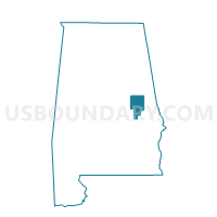
Daviston Community Center, Tallapoosa County, Alabama
About
Outline

Summary
| Unique Area Identifier | 522961 |
| Name | Daviston Community Center |
| County | Tallapoosa County |
| State | Alabama |
| Area (square miles) | 60.49 |
| Land Area (square miles) | 59.81 |
| Water Area (square miles) | 0.68 |
| % of Land Area | 98.88 |
| % of Water Area | 1.12 |
| Latitude of the Internal Point | 33.03984400 |
| Longtitude of the Internal Point | -85.66023670 |
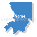
Maps


Graphs
Select a template below for downloading or customizing gragh for Daviston Community Center, Tallapoosa County, Alabama


Neighbors
Neighoring Voting District (by Name) Neighboring Voting District on the Map
- Buttston Vol. Fire Department, Tallapoosa County, AL
- Eagle Creek Voting House, Tallapoosa County, AL
- Jackson's Gap Vol. Fire Dept., Tallapoosa County, AL
- Mellow Valley H.S., Clay County, AL
- Mellow Valley High School Gym, Clay County, AL
- Milltown-Sparkling Springs Voting District, Chambers County, AL
- New Site Town Hall, Tallapoosa County, AL
- Union Hill, Chambers County, AL
- Wadley, Randolph County, AL
Top 10 Neighboring County Subdivision (by Population) Neighboring County Subdivision on the Map
- Dadeville CCD, Tallapoosa County, AL (11,896)
- Ashland CCD, Clay County, AL (6,128)
- New Site CCD, Tallapoosa County, AL (2,507)
- Wadley CCD, Randolph County, AL (2,112)
- Milltown CCD, Chambers County, AL (1,082)
Top 10 Neighboring Place (by Population) Neighboring Place on the Map
Top 10 Neighboring Unified School District (by Population) Neighboring Unified School District on the Map
- Chambers County School District, AL (27,747)
- Tallapoosa County School District, AL (22,443)
- Randolph County School District, AL (16,839)
- Clay County School District, AL (13,932)
Top 10 Neighboring State Legislative District Lower Chamber (by Population) Neighboring State Legislative District Lower Chamber on the Map
Top 10 Neighboring State Legislative District Upper Chamber (by Population) Neighboring State Legislative District Upper Chamber on the Map
Top 10 Neighboring 111th Congressional District (by Population) Neighboring 111th Congressional District on the Map
Top 10 Neighboring Census Tract (by Population) Neighboring Census Tract on the Map
- Census Tract 9624, Tallapoosa County, AL (4,703)
- Census Tract 9625.01, Tallapoosa County, AL (4,243)
- Census Tract 9538, Chambers County, AL (3,619)
- Census Tract 9591, Clay County, AL (2,904)
- Census Tract 9619, Tallapoosa County, AL (2,507)
- Census Tract 6, Randolph County, AL (2,112)